


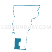
Winhall Voting District, Bennington County, Vermont
About
Outline

Summary
| Unique Area Identifier | 680717 |
| Name | Winhall Voting District |
| County | Bennington County |
| State | Vermont |
| Area (square miles) | 44.02 |
| Land Area (square miles) | 43.54 |
| Water Area (square miles) | 0.47 |
| % of Land Area | 98.92 |
| % of Water Area | 1.08 |
| Latitude of the Internal Point | 43.16897430 |
| Longtitude of the Internal Point | -72.97235940 |
Maps


Graphs
Select a template below for downloading or customizing gragh for Winhall Voting District, Bennington County, Vermont


Neighbors
Neighoring Voting District (by Name) Neighboring Voting District on the Map
- Dorset Voting District, Bennington County, VT
- Jamaica Voting District, Windham County, VT
- Landgrove Voting District, Bennington County, VT
- Londonderry Voting District, Windham County, VT
- Manchester Voting District, Bennington County, VT
- Peru Voting District, Bennington County, VT
- Stratton Voting District, Windham County, VT
- Sunderland Voting District, Bennington County, VT
Top 10 Neighboring County Subdivision (by Population) Neighboring County Subdivision on the Map
- Manchester town, Bennington County, VT (4,391)
- Dorset town, Bennington County, VT (2,031)
- Londonderry town, Windham County, VT (1,769)
- Jamaica town, Windham County, VT (1,035)
- Sunderland town, Bennington County, VT (956)
- Winhall town, Bennington County, VT (769)
- Peru town, Bennington County, VT (375)
- Stratton town, Windham County, VT (216)
- Landgrove town, Bennington County, VT (158)
Top 10 Neighboring Place (by Population) Neighboring Place on the Map
Top 10 Neighboring Elementary School District (by Population) Neighboring Elementary School District on the Map
- Manchester School District, VT (4,391)
- Dorset School District, VT (2,031)
- Jamaica School District, VT (1,035)
- Sunderland School District, VT (956)
- Winhall School District, VT (769)
Top 10 Neighboring Secondary School District (by Population) Neighboring Secondary School District on the Map
Top 10 Neighboring Unified School District (by Population) Neighboring Unified School District on the Map
Top 10 Neighboring State Legislative District Lower Chamber (by Population) Neighboring State Legislative District Lower Chamber on the Map
- Bennington-4 State House District, VT (4,391)
- Windham-Bennington-Windsor State House District, VT (4,355)
- Bennington-Rutland-1 State House District, VT (4,130)
- Bennington-5 State House District, VT (3,776)
Top 10 Neighboring State Legislative District Upper Chamber (by Population) Neighboring State Legislative District Upper Chamber on the Map
Top 10 Neighboring 111th Congressional District (by Population) Neighboring 111th Congressional District on the Map
Top 10 Neighboring Census Tract (by Population) Neighboring Census Tract on the Map
- Census Tract 9704, Bennington County, VT (4,391)
- Census Tract 9706, Bennington County, VT (3,084)
- Census Tract 9702, Bennington County, VT (2,031)
- Census Tract 9673, Windham County, VT (1,769)
- Census Tract 9705, Bennington County, VT (1,302)
- Census Tract 9675, Windham County, VT (1,119)
- Census Tract 9674, Windham County, VT (1,035)
Top 10 Neighboring 5-Digit ZIP Code Tabulation Area (by Population) Neighboring 5-Digit ZIP Code Tabulation Area on the Map
- 05255, VT (4,121)
- 05343, VT (917)
- 05155, VT (828)
- 05340, VT (763)
- 05253, VT (685)
- 05152, VT (448)
- 05252, VT (274)
- 05360, VT (251)